These are just a few of the weird and wonderful underwater creatures that you will learn about as part of our comprehensive science training course. For so many divers, even experienced ones, the new level of understanding of the marine environment that our training gives you really can prove revolutionary…
One of our key objectives has been the establishment and maintenance of a robust coral reef monitoring and biodiversity assessment programme. The number and geographical location of our survey sites means that there is work to be done all year round. When you join us on an expedition, our first task will be to train you how and why we assess the marine environment, and how marine habitat surveys are carried out.
Good question! Its not easy to describe in a way that gives you a clear picture. To help, we have put together a very short video that tries to give you a better idea.
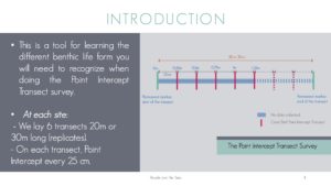
In short it is a structured, repeatable methodology that permits the collection of detailed information about the structure, composition and health of an underwater environment.
Good question! Its not easy to describe in a way that gives you a clear picture. To help, we have put together a very short video that tries to give you a better idea.
In short it is a structured, repeatable methodology that permits the collection of detailed information about the structure, composition and health of an underwater environment.
Many Filipino communities depends exclusively on its marine resources either through tourism or from fishing. However both activities can represent major threats to the marine environment and to the community if not managed and/or regulated. In order for these threats to be analysed, prioritised and answered, tourism and ecological data collection and monitoring is required.
People and the Sea aims to collect the data needed to support tourism and natural resources management, as well as advocacy efforts in infrastructure development and marine conservation legislation.
As explained by the IUCN guidelines:
“the establishment of a monitoring programme at the outset of project development, and the gathering of baseline information allows for early warning of impending changes, enabling timely management action to take place. It is therefore critically important to develop baseline data on initial conditions. The values placed on all subsequent monitoring data will depend upon the changes observed compared to the baseline data.” (Eagles et al, 2002)
Quantitative and qualitative data need to be collected during a significant period of time to be able to evaluate and prioritise the threats – and the benefits – generated from tourism to the community and the environment.
The training provided will give you all the information and training necessary. Likewise, no scientific background is required.
Our science training programme has been carefully developed to inspire you with the wonders of the underwater world. At the same time it will also train you in both the theory and practice of collecting reliable, accurate data about the condition of the marine habitats around the islands of Malapascua and Higatangan.
The science programme is delivered with the use of a variety of methods:
• A series of informal classroom presentations (see a selection of examples below)
• Numerous ‘dry’ practical exercises
• A series of ‘point-out’ training dives


Malapascua Island
We are afraid so!
The testing process is essential to ensure the validity of the data that we collect. There has been debate in the past as to whether information collected by volunteers in marine conservation organisations such as ours can be considered valid. Take a look at some of the research here.
We have full confidence in our training and assessment methods, and always work hard with expedition volunteers to make sure they reach the required standard.
Not a qualified diver?
That doesn’t mean you cannot join in. Our on site instructional team can teach a full range of world-recognised SCUBA courses. Take a look here for more information.
Of course, we understand that diving may not be for everyone. If that is the case, you are still able to get involved. A number of our surveys are conducted at sites accessible to snorkellers. It doesn’t matter how you get there, the information is still just as important and valid!